Naseby - a Visitor's Guide
Updated. As the Naseby Battlefield Project appear to want to steer you towards a guided tour of the battlefield, here's the information that you need for a self-guided tour.
Back in the day when this blog was knee high to a grasshopper I wrote an entry about visiting Naseby, with a picture of the obelisk and a few postcodes for some of the landmarks on the battlefield. I also vowed to return. I have (several times).
So here is a more definitive (and up to date) visitor's guide to Naseby battlefield. In my previous blog entry I suggested using a Battlefield Trail Guide from The Naseby Battlefield Project website, but this has disappeared from their website ; so, here is my guide to the locations. There were audio clips for each location (again via the Battlefield Project website) but these appear to have disappeared too.
The information boards are being updated, most sites have shiny new information boards in situ; some still have QR codes for the audio guide (don't try opening them, as the guide is no longer).
For each stop I will provide a Postcode (for car satnavs) and an Ordnance Survey grid reference ( OS Explorer Map 223). As rural postcodes can cover large areas I will say in the text for each point how accurate it is: if it is a bit vague I'll provide a photo and/or an OS grid reference to help you find parking.
Many of the sites are located on working farmland, please remember to follow the Countryside Code!
I started my tour at Fairfax's Viewpoint. Streeter's Plan is after all a plan of General Fairfax's army, plus Black Tom won, which is a good enough reason to start here. Postcode NN6 6BU (very accurate), OS grid SP 6979 7907. Those of you with a more Royalist leaning may wish to start at Rupert's Viewpoint and work backwards.


Obelisk Monument Postcode NN6 6DE (okay-ish) OS: SP 6934 7844. Parking in small layby on opposite side of the road. A flag pole has recently been erected in the field adjacent to the layby.
Either the Obelisk or Fairfax View was the site of the windmill in Streeter's Plan.


Next stop is Cromwell Monument and Blewcoat's Stone Postcode NN6 6BS (okay-ish) this parking is suitable for both sites.
The Cromwell Monument is well signposted, and parking is indicated (a layby close to the entrance to the Monument's path). OS: SP 6846 7998


Blewcoat's Stone this is a memorial stone for Prince Rupert's Regiment of Blewcoats who stood "like a wall of brass" and was laid by the Sealed Knot Regiment who re-enact the Blewcoats. It is sited 500m north of the Monument carpark (down the slope), located in the corner of the field whose gate is the first gate on the left after the entrance track to Broadmoor farm. OS: SP 6852 8049

Next stop Sulby Hedges. Follow the Postcode LE16 9UG (okay-ish) towards Sibbertoft: you'll approach some S-bends (road sign), as the road turns 90 degrees there is a farm entrance immediately on the left. There is a very faded brown/almost orange battlefield sign on the fingerpost. Park here. OS: SP 6794 8226. Please ensure you allow access for farm vehicles. The walk is popular with dog walkers, so there may already be vehicles parked here. If you see the Sibbertoft village name signs you've gone too far.


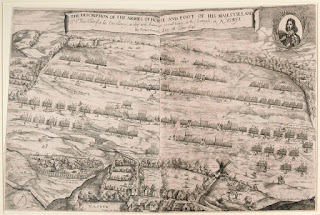
It is quite interesting having a copy of Streeter's Plan to hand - the landscape is, apparently very accurate, the troop formations probably less so. For more information about Streeter's Plan see here.
For each stop I will provide a Postcode (for car satnavs) and an Ordnance Survey grid reference ( OS Explorer Map 223). As rural postcodes can cover large areas I will say in the text for each point how accurate it is: if it is a bit vague I'll provide a photo and/or an OS grid reference to help you find parking.
Many of the sites are located on working farmland, please remember to follow the Countryside Code!
 |
| Very approximate location of the information boards |


Obelisk Monument Postcode NN6 6DE (okay-ish) OS: SP 6934 7844. Parking in small layby on opposite side of the road. A flag pole has recently been erected in the field adjacent to the layby.
Either the Obelisk or Fairfax View was the site of the windmill in Streeter's Plan.


As you head towards the Cromwell Monument your journey will take you into Naseby village.


All Saint's Church Postcode NN6 6DA (very accurate) has a small number of battlefield artefacts on display, and a table reputed to have been used by Cromwell. Opposite the church, is the village shop, where you can borrow the rather substantial key to open the church. One of the old information boards is located outside the church, and a very neglected information board is sited next to the shop.


 |
| The Cromwell Table, and if I'm not mistaken... the Fairfax fire extinguisher |
The Cromwell Monument is well signposted, and parking is indicated (a layby close to the entrance to the Monument's path). OS: SP 6846 7998


Blewcoat's Stone this is a memorial stone for Prince Rupert's Regiment of Blewcoats who stood "like a wall of brass" and was laid by the Sealed Knot Regiment who re-enact the Blewcoats. It is sited 500m north of the Monument carpark (down the slope), located in the corner of the field whose gate is the first gate on the left after the entrance track to Broadmoor farm. OS: SP 6852 8049

Next stop Sulby Hedges. Follow the Postcode LE16 9UG (okay-ish) towards Sibbertoft: you'll approach some S-bends (road sign), as the road turns 90 degrees there is a farm entrance immediately on the left. There is a very faded brown/almost orange battlefield sign on the fingerpost. Park here. OS: SP 6794 8226. Please ensure you allow access for farm vehicles. The walk is popular with dog walkers, so there may already be vehicles parked here. If you see the Sibbertoft village name signs you've gone too far.

 |
| Although don't be at all surprised if someone has turned the battlefield sign around |
Sulby Hedges viewing platform is about a fifteen/twenty minute walk from the parking area. Follow the bridleway, which is a good farm track until you see this:

The same spot with vegetation...

...then turn left onto a permissive path around the edges of the field, keep an eye out for the white topped posts. I challenge you not to walk around, close to the field edge, eyes downward searching for musket balls!


Those of you who turned left onto the permissive path: halfway to your destination you'll pass the King Charles's Oak site: a narrow footbridge takes you over a stream to some display boards. Colonel Okey reported seeing the King close to an ancient oak that once grew in this area.

Return to the path, and continue to Sulby Hedges.


Retreat View is located approximately 400 metres down the road, back towards Sibbertoft. Signposted for a bridleway the interpretation board is just through the gate. OS: SP 6859 8238

A permissive path to Moot Hill was located at the reservoir, however the landowner clearly doesn't want anyone on the land, the gates are covered in barbed wire and padlocked shut. The flagpole marking the site no longer has a flag. Discretion is the better part of valour.
Next stop the ROC Viewpoint. Parking - Postcode LE16 9TT (okay-ish) OS: SP 7033 8665 From here it is a hop skip and a jump to the WW2 Royal Observer Corps observation post which gives excellent views of the whole battlefield. May 2024 update alas, access to ROC Viewpoint is no longer permitted. (Included here for completeness, and the hope that things might change.)


Return to your car and carry straight on towards Marston Trussell Church Postcode LE16 9TY (very accurate) OS: SP 6930 8596. This is Pudding Bag End, which sounds like a Hobbit village from The Shire, but was in fact where Royalist horse fleeing the battlefield got trapped in a dead end and fought to the death.


Final battlefield stop is Prince Rupert's Viewpoint Postcode LE16 9SN (fairly accurate) OS: SP 7169 8417. Signposted, but the carpark is now closed. Update June 2020: the viewing platform has now been repaired and is safe to use. The car park remains closed.

Which leads us nicely into the retreat of the Royalist forces. Market Harborough has a Civil War Trail which completes the battlefield tour nicely. I found The Commons carpark Postcode LE16 9DB (very accurate) a good location for the trail and also the town centre. The information boards in Market Harborough have all had a major facelift (April 2024).
From the carpark return to the carpark entrance and turn left walking down Coventry Road (away from the town centre). Take the first left onto Farndown Road where you will see a footpath which runs beside the river (cunningly named Riverside Walk). Here is the first interpretation board - Bloodyman's Ford.

Follow the riverside walk for about a kilometre to Northampton Road Bridge.

Turn left along Northampton Road towards the town centre. You'll quickly come to the market cross, where The Bell Inn board is located

Cross the road and head toward St Dionysius's Church where Parliamentarians held between four and five thousand Royalist prisoners after the battle.

Stay on the main road and a few hundred metres further up you'll find the King's Head board.

Retrace your steps to St Dionysius's Church and the Old Grammar School

Behind the Old Grammar School is the Museum, which have a few (blink and you'll miss them) Civil war artefacts on display.


The same spot with vegetation...

...then turn left onto a permissive path around the edges of the field, keep an eye out for the white topped posts. I challenge you not to walk around, close to the field edge, eyes downward searching for musket balls!

If it is very muddy, and you have forgotten your wellies and you really don't want to ruin your shoes, don't turn left onto the permissive path, turn right and stay on the bridleway. This skirts the other boundary of the field and will deposit you almost at the viewing platform on well drained gravel track. The viewing platform is straight in front of you, and the track turns right and goes through a gateway.
Just through this gateway is a memorial bench commemorating battlefield historian and author Martin Marix Evans who passed away in 2020. Martin was the founder and initial driving force behind the Naseby Battlefield Project, which has done so much to improve the interpretation of the battle and make it a Northamptonshire visitor attraction.
Those of you who turned left onto the permissive path: halfway to your destination you'll pass the King Charles's Oak site: a narrow footbridge takes you over a stream to some display boards. Colonel Okey reported seeing the King close to an ancient oak that once grew in this area.
 |
Update June 2023 - the display boards at the King's Oak have been replaced (they disappeared for a while) |

Return to the path, and continue to Sulby Hedges.


 |
| Update June 2023: since my last visit in 2020, it looks like the interpretation boards have had a refresh |
Our next stop is Retreat View and Moot Hill. Postcode LE16 9UB (very accurate) OS: SP 6901 8228 There is parking for a car opposite the entrance to Lowe Farm, adjacent to the 'reservoir' marked on the OS map.

Retreat View is located approximately 400 metres down the road, back towards Sibbertoft. Signposted for a bridleway the interpretation board is just through the gate. OS: SP 6859 8238

A permissive path to Moot Hill was located at the reservoir, however the landowner clearly doesn't want anyone on the land, the gates are covered in barbed wire and padlocked shut. The flagpole marking the site no longer has a flag. Discretion is the better part of valour.
 |
| So close, yet so far... |


Return to your car and carry straight on towards Marston Trussell Church Postcode LE16 9TY (very accurate) OS: SP 6930 8596. This is Pudding Bag End, which sounds like a Hobbit village from The Shire, but was in fact where Royalist horse fleeing the battlefield got trapped in a dead end and fought to the death.


As you drive towards Prince Rupert's View along Sibbertoft Road towards Clipston spare a thought for the Royalist baggage train: the women, children and servants who made up the personnel of this train. Somewhere around the junction of Sibbertoft Road and Harborough Road in Clipston the New Model Army caught up with them. The atrocity that ensued at Farndon-field Harborough Road LE16 9RP is documented here, and why I believe it took place in the fields close to the junction (coming soon).
Final battlefield stop is Prince Rupert's Viewpoint Postcode LE16 9SN (fairly accurate) OS: SP 7169 8417. Signposted, but the carpark is now closed. Update June 2020: the viewing platform has now been repaired and is safe to use. The car park remains closed.

Which leads us nicely into the retreat of the Royalist forces. Market Harborough has a Civil War Trail which completes the battlefield tour nicely. I found The Commons carpark Postcode LE16 9DB (very accurate) a good location for the trail and also the town centre. The information boards in Market Harborough have all had a major facelift (April 2024).
From the carpark return to the carpark entrance and turn left walking down Coventry Road (away from the town centre). Take the first left onto Farndown Road where you will see a footpath which runs beside the river (cunningly named Riverside Walk). Here is the first interpretation board - Bloodyman's Ford.

Follow the riverside walk for about a kilometre to Northampton Road Bridge.

Turn left along Northampton Road towards the town centre. You'll quickly come to the market cross, where The Bell Inn board is located

Cross the road and head toward St Dionysius's Church where Parliamentarians held between four and five thousand Royalist prisoners after the battle.

Stay on the main road and a few hundred metres further up you'll find the King's Head board.

Retrace your steps to St Dionysius's Church and the Old Grammar School

Behind the Old Grammar School is the Museum, which have a few (blink and you'll miss them) Civil war artefacts on display.


Just outside Market Harborough, close to the village of Lubenham, are the remains of Papillon Hall, where it is said Charles spent the night before Naseby. The Hall was a grand affair, but was demolished in the 1950s. Little remains of it bar the surrounding wall and a few outbuildings. The entrance can be found on Old Hall Lane, LE16 9TJ. There are a number of buildings in the village that witnessed these events, and if you have time, it is well worth the short stroll.
Selected Bibliography
Naseby The Decisive Campaign G. Foard, Pen and Sword BooksIf you enjoyed reading this, or any of the other posts, please consider supporting the blog.
Thanks.


Really useful. I will use this information when I visit in the summer. Thank you.
ReplyDeleteYou are very welcome. My original Naseby post grew out of frustration at struggling to find the viewpoints. Enjoy your visit
DeleteSeconding what GH said. Really useful post. Appreciate the time taken to do this.
ReplyDeleteThank you. It wasn't too erroneous a task to be honest. Quite enjoyed doing it.
DeleteMany thanks for this! A very useful asset. Will definitely use this when next in the area.
ReplyDeleteThanks. Eek! Hope you don't get lost following my destructions
DeleteExcellent post, very helpful with the church and Market Harborough sections which are not included in the paid for tours.
ReplyDeleteThanks PDL
DeleteThank you so much for this, just did it on the weekend and instructions were superb!
ReplyDeletePity re the ROC viewpoint (seems so petty but what can you do)
Good to hear that the instructions work. Hope you had a good day
Delete