The Battles of Powick Bridge 1642 and Worcester 1651
The ECW Travelogue packed it's passport and headed down south again, this time revisiting Worcester. This time I looked at a lot more than just the Commandery.
The Battle of Powick Bridge, 23rd September 1642
Powick is often called the first battle of the English Civil War: which fails to acknowledge events in
Ireland, Hull, Southam, and Portsmouth. Plus the term 'battle' is over egging the pudding somewhat.
More accurately a cavalry skirmish Powick saw the well led, and enthusiastic Royalist cavalry of Prince Rupert, come up against well equipped but far less effective Parliamentarian cavalry under Nathaniel Fiennes. The Parliamentarians were routed, fleeing back across the bridge giving the Royalists a major propaganda victory.
The Battle of Worcester, 3rd September 1651
Worcester is also somewhat inaccurately termed the last battle of the English Civil War, although this time the claim is a little more accurate than that claimed for Powick being the first. Worcester was the last major battle of the Third Civil War: fighting continued in the Channel Isles, the colonies, on the high seas and in Scotland after Worcester.
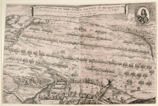
This time Parliament had the upper hand with 28000 well trained and well equipped soldiers of the New Model Army. King Charles II had a ragtag army beset with dysentery, 16000 strong consisting of mainly Scottish soldiers with limited artillery and precious little powder for those they had.
Parliament attacked from the south of the city - vicious fighting took place around Powick Bridge and the Teme meadow (bridges of boats had been built to facilitate Parliament's men crossing the Teme and Severn), whilst Worcester itself was attacked from the east.
The King got the upper hand in the fighting to the east, but this turned when reinforcements arrived from the south. The bloody slaughter at the south saw the Scots forced back to the city. Once the eastern assault turned in Parliament's favour the battle was pretty much done and dusted apart from fighting in the streets of Worcester. The Scots were left to their fate, whilst the King and his English troops fled the city.
What's There Now?
Parking in Worcester can be tricky, the closest car park to the Commandery/Cathedral is King Street, but this is usually very oversubscribed - try Commandery Road Car Park instead as it usually has spaces.
Worcester itself has as the jewel in it's crown the Commandery building and situated behind it Fort Royal, the site of a sconce and artillery positions.
In the town itself is King Charles House, now a pub, from where Charles II made his escape after the battle (apparently out of the back door as Parliamentarian soldiers were coming through the front).
King Charles House is located on New Street, a continuation of Friar Street, possibly the most picturesque part of Worcester, as it contains many buildings that were standing during the battle.
The Guildhall has statues of Kings Charles I and Charles II on either side of it's main entrance.

A strange figure with his ears pinned to the archway above the door is reputed to be Oliver Cromwell.
There are a number of markers around the city showing the course of the old city walls, in places remnants of the wall remain. A large plaque is located at St Martin's Gate, very close to King Charles House.
Worcester Cathedral is home to the last resting place of William Hamilton, 2nd Duke of Hamilton. He died of his wounds at the Commandery, he was buried near the altar in the Cathedral and there is a memorial to him in the north choir. Royalist prisoners were locked in the Cathedral's undercroft after their defeat in 1651.
Powick Bridge has a couple of memorials - one to the battles, the other to the Scots who fell. The Scottish memorial has recently been relocated next to the bridge due to the building of a relief road. There used to be an information board but this has been removed - the frame it sat in is still there. (Due to the roadworks the 'traditional' parking spot for Powick Bridge visitors is no longer available, the lane that goes to the bridge itself has limited parking spots available for non-residents. Please park considerately if parking here.) Powick Bridge is one of the first stops on The Monarch's Way a 615 mile walking route which follows the route taken by Charles II to France from Worcester (he went the long way round).
A good vantage point to view the fighting in the Teme Meadows is the Battlefield Vantage Point.
Powick Church bears the scars of musket balls from the 1651 battle: the Church has plans to build a visitor centre for the battles. There are a small number of parking spaces at the church, the turning for the church is easily missed (even though it is signposted), it is immediately on your left after Red Lion as you join the B4424 after the 'strange' roundabout.
Further out from the city centre is a green space at the end of Tamar Close. This roughly square flat(ish) field has what appears to be a ditch running around three of its four sides. This ditch is the remains of a gun battery earthwork was begun in May 1646 by Thomas Rainsborough's men who accepted the surrender of 102 Royalist troops in July of that year. The battery was most likely reused by Cromwell's men in 1651.
Postcodes for SatNavs
Commandery Road Car Park WR1 2HY
The Battle of Powick Bridge, 23rd September 1642
Powick is often called the first battle of the English Civil War: which fails to acknowledge events in
Ireland, Hull, Southam, and Portsmouth. Plus the term 'battle' is over egging the pudding somewhat.
More accurately a cavalry skirmish Powick saw the well led, and enthusiastic Royalist cavalry of Prince Rupert, come up against well equipped but far less effective Parliamentarian cavalry under Nathaniel Fiennes. The Parliamentarians were routed, fleeing back across the bridge giving the Royalists a major propaganda victory.
The Battle of Worcester, 3rd September 1651
Worcester is also somewhat inaccurately termed the last battle of the English Civil War, although this time the claim is a little more accurate than that claimed for Powick being the first. Worcester was the last major battle of the Third Civil War: fighting continued in the Channel Isles, the colonies, on the high seas and in Scotland after Worcester.
This time Parliament had the upper hand with 28000 well trained and well equipped soldiers of the New Model Army. King Charles II had a ragtag army beset with dysentery, 16000 strong consisting of mainly Scottish soldiers with limited artillery and precious little powder for those they had.
Parliament attacked from the south of the city - vicious fighting took place around Powick Bridge and the Teme meadow (bridges of boats had been built to facilitate Parliament's men crossing the Teme and Severn), whilst Worcester itself was attacked from the east.
The King got the upper hand in the fighting to the east, but this turned when reinforcements arrived from the south. The bloody slaughter at the south saw the Scots forced back to the city. Once the eastern assault turned in Parliament's favour the battle was pretty much done and dusted apart from fighting in the streets of Worcester. The Scots were left to their fate, whilst the King and his English troops fled the city.
What's There Now?
Parking in Worcester can be tricky, the closest car park to the Commandery/Cathedral is King Street, but this is usually very oversubscribed - try Commandery Road Car Park instead as it usually has spaces.
Worcester itself has as the jewel in it's crown the Commandery building and situated behind it Fort Royal, the site of a sconce and artillery positions.
King Charles House is located on New Street, a continuation of Friar Street, possibly the most picturesque part of Worcester, as it contains many buildings that were standing during the battle.
The Guildhall has statues of Kings Charles I and Charles II on either side of it's main entrance.

A strange figure with his ears pinned to the archway above the door is reputed to be Oliver Cromwell.
There are a number of markers around the city showing the course of the old city walls, in places remnants of the wall remain. A large plaque is located at St Martin's Gate, very close to King Charles House.
Worcester Cathedral is home to the last resting place of William Hamilton, 2nd Duke of Hamilton. He died of his wounds at the Commandery, he was buried near the altar in the Cathedral and there is a memorial to him in the north choir. Royalist prisoners were locked in the Cathedral's undercroft after their defeat in 1651.
Powick Bridge has a couple of memorials - one to the battles, the other to the Scots who fell. The Scottish memorial has recently been relocated next to the bridge due to the building of a relief road. There used to be an information board but this has been removed - the frame it sat in is still there. (Due to the roadworks the 'traditional' parking spot for Powick Bridge visitors is no longer available, the lane that goes to the bridge itself has limited parking spots available for non-residents. Please park considerately if parking here.) Powick Bridge is one of the first stops on The Monarch's Way a 615 mile walking route which follows the route taken by Charles II to France from Worcester (he went the long way round).
A good vantage point to view the fighting in the Teme Meadows is the Battlefield Vantage Point.
Powick Church bears the scars of musket balls from the 1651 battle: the Church has plans to build a visitor centre for the battles. There are a small number of parking spaces at the church, the turning for the church is easily missed (even though it is signposted), it is immediately on your left after Red Lion as you join the B4424 after the 'strange' roundabout.
Not far from the Powick Bridge site is where the bridge of boats was built. Drive carefully down Dace Road (it is a quiet cul-de-sac type estate with lots of children playing), passing Carp Close on your right then park. A footpath goes down to the river on the left hand side of the road (as you have approached it). Follow this footpath downhill towards the river, go through the large metal gates and turn left. A short walk will bring you to a wooden platform opposite the confluence of the Rivers Severn and Teme, where there is an information board.
 |
| The old information board at the bridge of boats: this has been recently replaced, and a wooden viewing platform installed. |
 |
| The confluence of the Severn (foreground) and Teme |
Further out from the city centre is a green space at the end of Tamar Close. This roughly square flat(ish) field has what appears to be a ditch running around three of its four sides. This ditch is the remains of a gun battery earthwork was begun in May 1646 by Thomas Rainsborough's men who accepted the surrender of 102 Royalist troops in July of that year. The battery was most likely reused by Cromwell's men in 1651.
Commandery Road Car Park WR1 2HY
The Commandery WR1 2HU
Fort Royal WR5 2DJ
Worcester Cathedral WR1 2LA
King Charles House WR1 2DP
Friar Street WR1 2NT
Guildhall WR1 2EY
City Walls plaque, St Martin's Gate WR1 2DU
Battlefield Viewpoint WR5 3HW
Powick Bridge WR2 4BU
St Peter and St Lawrence Church, Powick WR2 4QT
Dace Road, Broomhall WR5 3FD
Tamar Close WR5 1NE
If you enjoyed reading this, or any of the other posts, please consider supporting the blog.
Thanks.


Charles I arriving at the Oxford wargaming club with his new 30mm scale church.
ReplyDeleteChapeau! Well spotted. Although it took me a moment to think about.
DeleteWonderful post Radar! It has me thinking about a "Catch the King Scenario" with Parliamentarian troops running along the streets trying to find Charles.
ReplyDeleteThanks Codsticker. Could make a good film script too, if done well and not hammed up like Scarlet Blade
DeleteYou may wish to revisit Powick Old Bridge ad its wing wall has collapsed due to excessive debris buildup and potentially foundation damage as the debris was being removed. Go checkout our page created by Worcester Civic Society called “Friends of Powick Old Bridge’, its not a pretty site with tonnes of gravel bags building a platform for the arch support to be installed hopefully as soon as possible before the true winter floods arrive
ReplyDeleteI was saddened to see the damage to the bridge caused by the flooding in February and have been watching developments from afar (courtesy of updates from the Battle of Worcester Society and the Battlefields Trust). Considering the historical importance of the site I was surprised that it has taken so long to start the stabilisation and protection works. Fingers crossed that the water levels stay low whilst this work is undertaken.
Delete